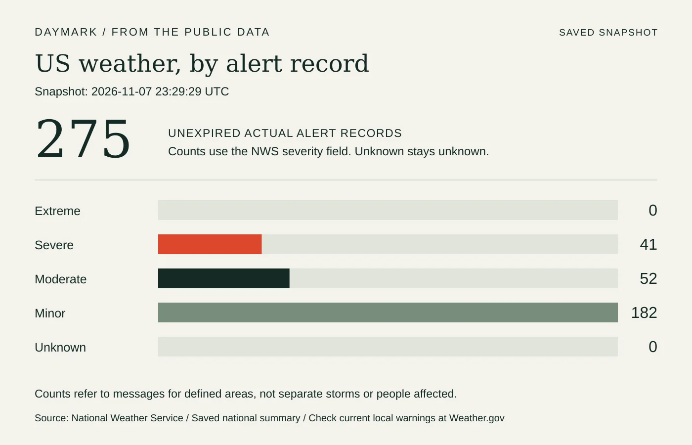
The alerts at the snapshot time
Nov 7, 11:29 PM UTC- Unexpired records
- 275
- Severe classification
- 41
- Extreme classification
- 0
These are saved NWS message counts, not separate storms or people affected. Warnings can change between scheduled updates. Check current local warnings at Weather.gov ↗.
View all event-label counts
| Event label | Records |
|---|---|
| Small Craft Advisory | 155 |
| Gale Warning | 24 |
| Flood Warning | 12 |
| Frost Advisory | 12 |
| Heavy Freezing Spray Warning | 11 |
| Coastal Flood Advisory | 7 |
| Beach Hazards Statement | 6 |
| Freeze Warning | 6 |
| Hazardous Seas Warning | 6 |
| Wind Advisory | 6 |
| High Surf Advisory | 5 |
| Rip Current Statement | 4 |
| Storm Warning | 4 |
| High Wind Warning | 3 |
| Coastal Flood Statement | 2 |
| Flood Watch | 2 |
| Hazardous Seas Watch | 2 |
| High Surf Warning | 2 |
| High Wind Watch | 2 |
| Dense Fog Advisory | 1 |
| Flood Advisory | 1 |
| Lake Wind Advisory | 1 |
| Red Flag Warning | 1 |
What the snapshot shows
As of November 7, 2026, 23:29 UTC, the National Weather Service feed contained 275 unexpired alert records. Its source update was November 7, 2026, 23:25 UTC. The severity fields recorded 0 Extreme, 41 Severe, 52 Moderate, 182 Minor, and 0 Unknown records. These are messages for defined areas, not separate storms or a count of people affected.
The source labels these messages Actual, meaning they are operational alerts rather than tests or exercises. That status does not mean that forecast conditions have already happened.
The most frequent event labels in this snapshot were Small Craft Advisory: 155; Gale Warning: 24; Flood Warning: 12; Frost Advisory: 12. Repeated labels can cover different zones or issuing offices. Several messages may concern the same weather system, and one record can cover several named areas. The graphic counts messages as reported, without adding together populations or treating an advisory as a confirmed incident.
Read the time and the place together
An alert can already be issued while the conditions it concerns are expected later. The sent time identifies the message; its onset and ending fields describe the source’s stated period when supplied. The expiry is the lifetime of that message, which can differ from the ending time. This report keeps those labels separate. It does not convert an expected event into an observation that it has happened.
The records below are ordered by the source severity field, then by issuance time, and show the first six. That order helps find the higher severity labels without assigning a new forecast. Check the named area against your own location, and open the source message for its complete description, instructions, revisions, and cancellations. A national summary cannot replace a local warning.
Storm Warning · NWS Juneau AK
Covered area: Gulf of Alaska South of 57 Degrees North and East of 144 W.
NWS classifies this alert as Severe. Sent: November 7, 2026, 23:05 UTC. Effective: November 7, 2026, 23:05 UTC. Message expiry: November 8, 2026, 17:15 UTC.
Source onset: November 9, 2026, 02:00 UTC. Source ending: November 9, 2026, 14:00 UTC. Check the official message for current instructions and revisions.
Storm Warning · NWS Seattle WA
The source's longer area list begins: Coastal Waters From Cape Flattery To James Island Out 10 Nm; Coastal Waters From James Island To Point Grenville Out 10 Nm; Coastal Waters From Point Grenville To Cape Shoalwater Out 10 Nm; Coastal Waters From Cape Flattery To James Island 10 To 60 Nm; Waters From James Island To Point Grenville 10 To 60 Nm. Open the official message for the complete covered-area list.
NWS classifies this update as Severe. Sent: November 7, 2026, 22:39 UTC. Effective: November 7, 2026, 22:39 UTC. Message expiry: November 8, 2026, 06:45 UTC.
Source onset: November 7, 2026, 22:39 UTC. Source ending: November 8, 2026, 18:00 UTC. Check the official message for current instructions and revisions.
Flood Watch · NWS Corpus Christi TX
Covered area: La Salle; McMullen; Live Oak; Bee; Goliad; Webb; Duval; Jim Wells; Inland Kleberg; Inland Nueces; Inland San Patricio; Coastal Aransas; Inland Refugio; Coastal Kleberg; Coastal Nueces; Coastal San Patricio; Aransas Islands; Coastal Refugio; Kleberg Islands; Nueces Islands.
NWS classifies this alert as Severe. Sent: November 7, 2026, 21:57 UTC. Effective: November 7, 2026, 21:57 UTC. Message expiry: November 8, 2026, 12:00 UTC.
Source onset: November 7, 2026, 21:57 UTC. Source ending: November 9, 2026, 18:00 UTC. Check the official message for current instructions and revisions.
Freeze Warning · NWS Charleston WV
Covered area: Greenup; Carter; Boyd; Lawrence; Lawrence; Dickenson; Buchanan; Wayne; Cabell; Lincoln; Putnam; Kanawha; Mingo; Logan; Boone; Clay; McDowell; Wyoming.
NWS classifies this update as Severe. Sent: November 7, 2026, 21:37 UTC. Effective: November 7, 2026, 21:37 UTC. Message expiry: November 8, 2026, 05:45 UTC.
Source onset: November 8, 2026, 05:00 UTC. Source ending: November 8, 2026, 15:00 UTC. Check the official message for current instructions and revisions.
Freeze Warning · NWS Jackson KY
Covered area: Fleming; Montgomery; Bath; Rowan; Estill; Powell; Menifee; Rockcastle; Jackson; Pulaski; Laurel; Wayne; McCreary; Whitley; Knox; Bell; Harlan; Elliott; Morgan; Johnson; Wolfe; Magoffin; Floyd; Lee; Breathitt; Knott; Owsley; Perry; Clay; Leslie; Letcher; Martin; Pike.
NWS classifies this update as Severe. Sent: November 7, 2026, 21:30 UTC. Effective: November 7, 2026, 21:30 UTC. Message expiry: November 8, 2026, 13:00 UTC.
Source onset: November 8, 2026, 05:00 UTC. Source ending: November 8, 2026, 15:00 UTC. Check the official message for current instructions and revisions.
High Wind Warning · NWS Seattle WA
Covered area: Northern Washington Coast; Grays Harbor County Coast.
NWS classifies this update as Severe. Sent: November 7, 2026, 21:17 UTC. Effective: November 7, 2026, 21:17 UTC. Message expiry: November 8, 2026, 07:30 UTC.
Source onset: November 8, 2026, 00:00 UTC. Source ending: November 8, 2026, 12:00 UTC. Check the official message for current instructions and revisions.
Where to check the latest warning
Weather.gov provides the current hazards map and local forecast search. Official alerts can update between this site’s scheduled refreshes. Use NOAA Weather Radio, Wireless Emergency Alerts, your local weather office, and local emergency officials for time-sensitive decisions. This saved report is background reading and cannot deliver an emergency notification.
The updater uses the NWS Actual feed, excludes expired messages and cancellations, and removes returned messages that an update or cancellation explicitly replaces. It preserves the last validated snapshot if a request fails. A retained report keeps its recorded times. Unknown severity remains unknown, and a valid empty response is never described as a guarantee of safe weather. The source messages and the NWS service documentation are linked below.
Sources
- National Weather Service: current hazards and local forecasts
- NWS: Actual active-alert source feed
- Storm Warning: NWS Juneau AK source message
- Storm Warning: NWS Seattle WA source message
- Flood Watch: NWS Corpus Christi TX source message
- Freeze Warning: NWS Charleston WV source message
- Freeze Warning: NWS Jackson KY source message
- High Wind Warning: NWS Seattle WA source message
- NWS: API documentation and open-data terms
- NWS: data-use and timeliness notice
Our editorial standards explain how sources and automated briefings are handled.